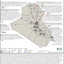
ISIS Sanctuary Map: August 8, 2014
Aug 4, 2015 - Institute for t...ISW has updated its ISIS Sanctuary map. This map, covering both Iraq and Syria, shows the extent of ISIS zones of control, attack, and support throughout both countries.
ISW has updated its ISIS Sanctuary map. This map, covering both Iraq and Syria, shows the extent of ISIS zones of control, attack, and support throughout both countries.

The government of Prime Minister (PM) Haidar al-Abadi is taking active steps toward decentralization by allowing approval of the Provincial Powers Act, also known as Law 21, which transfers powers from the central to the provincial governments.
ISW has updated its ISIS Sanctuary map. This map, covering both Iraq and Syria, shows the extent of ISIS zones of control, attack, and support throughout both countries.

The Iraqi Security Forces (ISF), supported by U.S.-led Coalition airpower, have continued to report advances north and south of Ramadi while simultaneously repelling ISIS’s attacks east of the city.

The Iraqi Security Forces (ISF), including the Counter Terrorism Service, U.S.-trained Iraqi Army units, Iraqi Police, Federal Police, supported by Iraqi Air Force and U.S.-led Coalition airstrikes, have advanced east and south of Ramadi amid the high-profile operation that was publicly discussed during Secretary of Defense Ashton Carter’s visit to Iraq last week.

The recent deterioration of security in Diyala has generated competing requirements for Iranian proxy forces following the deployment of the Badr Organization and other groups into Anbar, their furthest deployment in Sunni areas of Iraq to date.

The Iraqi government is experiencing competing pressures from dispersed ISIS attacks which have strained the capacity of both the Iraqi Security Forces (ISF) and the “Popular Mobilization.”

On July 16, 2015, the Interior Ministry (MoI) confirmed that Iraq closed the Trebil border crossing temporarily, but did not elaborate on when the crossing would be reopened.

