 |
 |
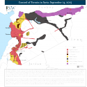
Control of Terrain in Syria: September 14, 2015

Since ISW last published a Control of Terrain in Syria map in June, the Islamic State of Iraq and al-Sham (ISIS) seized the town of Qaryatayn in the Eastern Qalamoun region on August 5 following a brief offensive. The key crossroads town provides ISIS with opportunities to conduct further advances in the direction of Damascus, Homs City, or the strategic T4 (Tiyas) Airbase. ISIS fighters also conducted several attacks against Hezbollah positions along the Lebanese border southwest of Qusayr in Homs Province, highlighting the presence of active ISIS forces in the region. Meanwhile, Jabhat al-Nusra (JN), Ahrar al-Sham, and other rebel factions participating in the Jaysh al-Fatah Operations Room advanced into the al-Ghab Plain in northwestern Hama Province, directly threatening the coastal regime heartland in Latakia Province. JN and other rebel forces also seized the besieged Abu Dhuhur Military Airbase in eastern Idlib Province, leaving the two pro-regime towns of Fu’ah and Kefraya northeast of Idlib City as the only remaining regime presence in the province.
ISW has modified its Control of Terrain in Syria map to order to highlight the terrain which is assessed to be under the predominant control of Lebanese Hezbollah rather than the Syrian regime. Hezbollah seized the town of Qusayr southwest of Homs City in an offensive over April to June 2013 which marked its first overt intervention into the Syrian Civil War. Hezbollah later played a key role in a major operation which cleared rebel forces from Yabroud and other towns along the M5 Highway between Damascus and Homs. Hezbollah launched a new offensive in May 2015 to eliminate the remaining rebel presence in the Qalamoun Mountains along the border with Lebanon, including the besieged rebel-held town of Zabadani northwest of Damascus. The addition of a new zone of control to the map thus reflects the dominance of Hezbollah along the Syrian-Lebanese border.